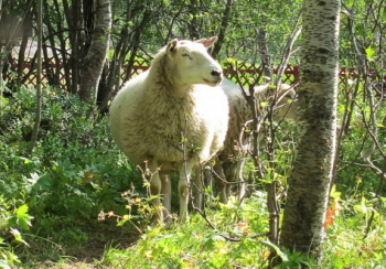
Between clusters of birch trees, sheep munch on greenery, eyeing me through the rope fence. I’m walking through Gruvstads park. It’s a peaceful scene. There are gently sloping paths leading to benches, a place to view some homely chickens, a wood store and a place to barbecue, and children’s swings.
Paths meander pleasantly through the park, passing fine examples of Kiruna’s old houses – the Chief Engineer’s house, for instance, and the mining company’s own hotel – visited by the great and the good of Sweden from 1910 onwards. (During the previous King’s visit, our neighbour’s son was called in to mend a broken window frame. In those days, Kiruna did royal visits in style.) The first mine director, Lundbohm – credited with establishing the town of Kiruna – lived in a small unpretentious house here, with a good view out over the mine. The building is still there, now a museum and a café.
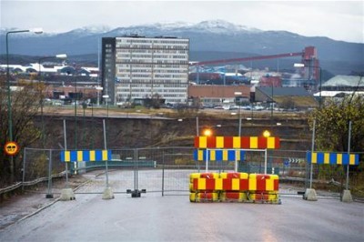
Appearances in this town, though, can be deceptive. Round the corner from all this serenity and the calmly munching sheep is this:

Beyond the fence you can see where the land has collapsed just in front of the mine’s main office building. It was a road I can remember running down twenty years ago. Since then the land has collapsed, and the road has had to be shut off for safety reasons. This is the hole that will eventually swallow up the town, and first in line is Gruvstads park.
Something new just appeared in Gruvstads park – giant reproductions of photographs of old Kiruna, positioned so they show the scene roughly where you stand, so you can compare them to what’s there today. In Kiruna an exhibition of something is a sure sign that it’s about to disappear. In the town hall now there’s an exhibition about the English architect Ralph Erskine who designed the blocks of flats known as ‘the spitting cup’ and ‘the Berlin wall’. You can see Gruvstads park from these flats – they’re just the other side of the road….
In the mine’s own special language, Gruvstads park is ‘a moving oasis’. To you and me, that’s a park which is repeatedly moved as parts of it fall into a pit. The area marked out on town plans is wider than the current park – it includes roads, the railway station (already out of use – there’s a hut up the road now instead), the town hall, the library, housing and shops. This is Gruvstads park 1, and slowly all those roads and buildings will be emptied, knocked down and the area will become a park, and then later, a pit.
There was a big fanfare a few weeks ago when the local council signed an agreement with the mine about compensation to the town for this area. The council are pleased – now they have the money to rebuild the public buildings. It looks like an agreement to help them ‘kick-start’ (as they keep saying) the building of the new town (and God knows they need a kick-start, or maybe just a kick). The trouble is, they’ve left negotiations over businesses and housing to the mine to sort out, and we don’t know how or when this will happen. So only part of the town is ready to be rebuilt. Will there be a town of public buildings in one place, and the rest of us still living somewhere else?
It’s a confusing picture. But we do know that in years to come there will be plenty of places where sheep may safely graze.

